Trip9 Ball Pass
Date:
6/11/05 - 8/10/05
Highlights
- high pass near Mt Cook
- precipitous terrain
- stunning panoramic views everywhere you look
Route
Start at Mt Cook Village
Camp in upper Hooker valley
Ball Shelter Hut
Return
Trip log:
Day 1 9km +500m
Day 2 12km +1000m
Day 3 9km +100m
walked= 30km +1600m=total climb
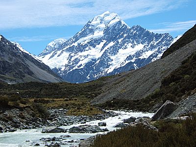
After my Mt Cook apprenticeship in the Mueller range I have to say I am heartily glad to be entering some new terrain. Leaving the village you cross the hooker bridge and go through an unmarked gate along an unmarked trail up the true left of the Hooker glacier.
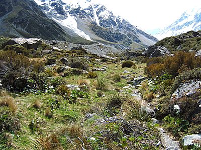
Its really very pretty, and conjures up images of Switzerland in my mind.
You get a first hand view of the Hooker terminus. It looks like lava which just suddenly stopped
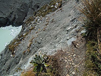
At several places the trail just drops away into nothingness. Up north erosion is a thing of bad management. Around here its just a fact of life--the mountains are constantly in motion and there`s not a thing you could do about it even if you wanted to.
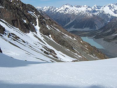
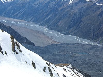
Looking directly across the glacier, you can clearly see (lower left) the now stranded Hooker Hut. For all practical intents its unreachable, because of steeply gouged moraine. You can also see Copland Pass (now more difficult), above centre right.
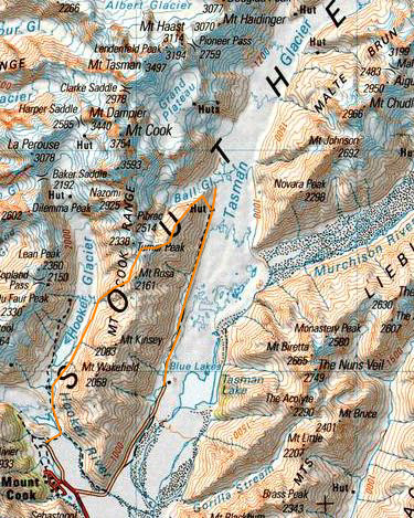
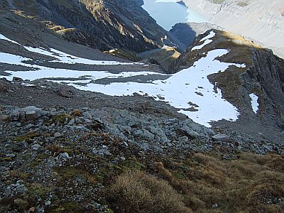
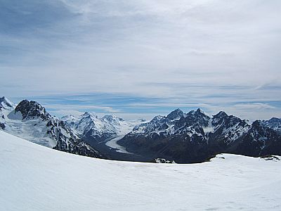
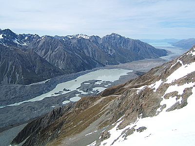
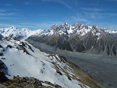
Heres a view of the entire Ball Pass route, taken a few days ago.
Ball Pass is the dip in the upper center. The route up is the narrow snowy gut dead center. The Hooker camp is just beneath that
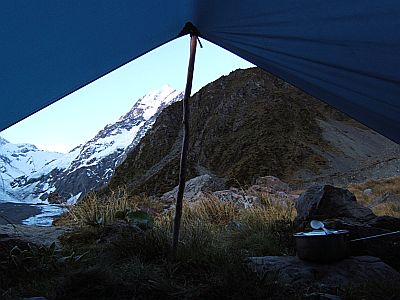
My fly camp, in extraordinary (by comparison) weather at the foot of the ball pass route. It`s a nice semi-sheltered tussocky flat. There`s water from a little waterfall nearby.
A pre 6am start proves a good idea to get the best of the snow conditions but also the heat yesterday was so great that I drank 2 litres of water just walking up the valley! I was packing 4 for the trip up and over the pass, and climbing in the cool of the morning helps a lot. This photo is from the top of the snow gut, some 400m vertical later. The flatish bump is a waypoint known as the playing fields. From there the route guide appears to me to over explicit. You just climb, picking a way through bluffs to about 1800m, then traverse left. You can either zigzag, or just go straight up as I did, in some cases on front points (afterall we cant have this being too pedestrian).
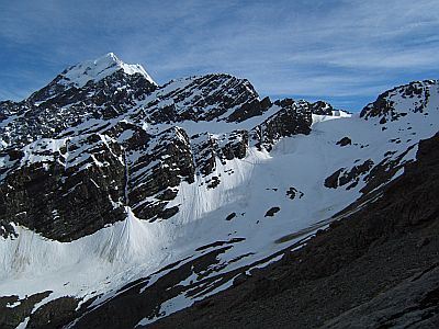
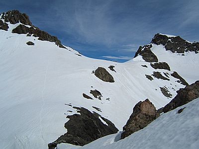
You then sidle across a rock field, dip briefly below a spur (at left), then climb easy snowfields to the pass top right.
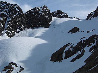
Getting closer. We are approaching from the right, up high. The sun is just starting to pop over the pass. Doing it West-East gives you the benefit of the morning shade. It also avoids climbing what I now know to be dreadful east snow conditions. You sort of know when the results of your route planning deliberations stack up into a coherent trip and it`s a good feeling.
Getting much closer. The footsteps are those of an E-W party yesterday afternoon. They cooked and dehydrated and wallowed in soft snow. There`s very few crossing it at the moment. Two parties tried last week and turned back because of the wind.
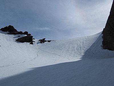
The last view back west, showing clearly the spur you sidle under, and the point on the ridge (where it eases) on the horizon where you turn after the playing field zigzags.
This is the other reason you do it W-E that I didn`t know about. In economics those are call positive externalities, ie unintended side effects. You enter quite suddenly and dramatically this whole splendid world of magical mountains. Photos don`t really do this area justice, your mouth just drops and you sit there just spacing out. Its really quite far out. Tasman saddle is in the middle distance, Cinerama Col at left, Malte Brun at right.
(Looking back at pass). For the best vantage point though cross the pass some, and proceed to the first bump on the descent ridge, at right just off picture.
From there: Cinerama col is one of the main entrances to the grand plateau which is just beneath Mts Cook and Tasman.
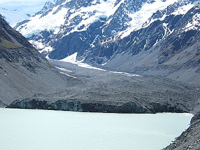
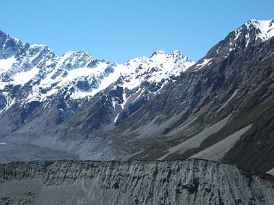
The Murchison River hits the Tasman Moraine. Its simply vast, and id like to go down there one day.
The Tasman terminal lake is growing quite rapidly, as the glacier recedes through global warming. Lake Pukaki in the far distance.
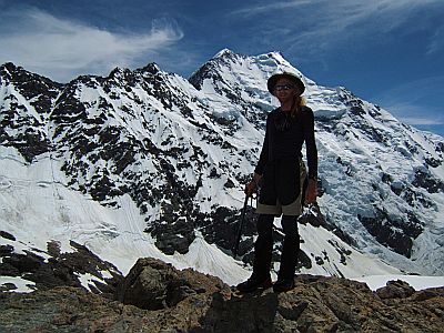
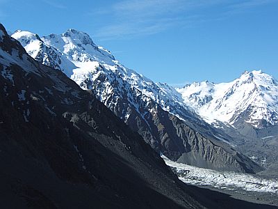
The climber, hot in just one layer of thermals. Low, and middle peaks behind.
The route down just follows the ridge the whole way. Caroline Hut, low center is a private hut used by a company which does guided Ball Pass trips. All I can say is it`s a great spot for a hut, and why doesn`t DoC build a few like it. As it is the park is losing one hut every other year to natural causes, they call them avalanches and ground slumps, I call it entropy. If you don`t apply energy to maintain assets, in time you wont have assets. Simple but true. After all avalanches around here are sort of normal, a bit like road crashes. To stop building huts, is like to stop building cars.
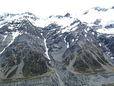
Malte Brun range. Malte Brun Pass is in there somewhere and that is one of the other trips suitable suggested by the ranger.
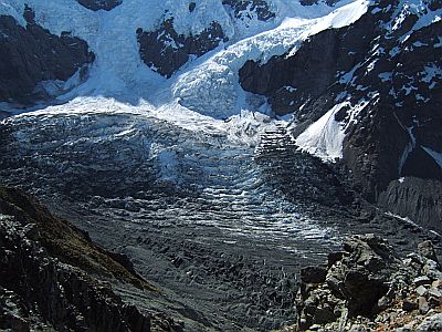
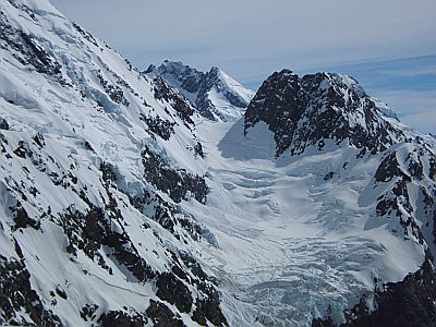
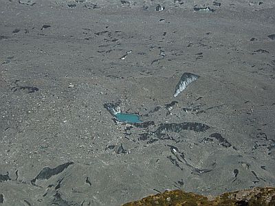
Ball Glacier is immediately to our left and straight below us. It`s a groaning, cracking, humming sort of place like most active glaciers are.
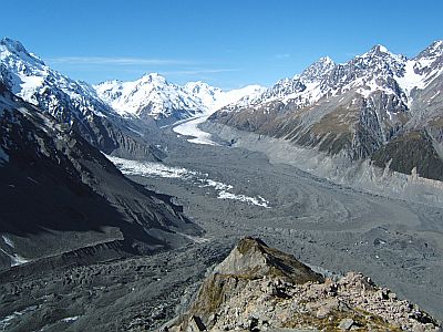
Ball glacier to lower left, and the Hochstetter outfall hits the tasman at left in a broad curving waves. To get to Haast Ridge of other points north you have to go around that outfall, walking up the glacier, walking as you are on 600m thick ice (with a meter or so of gravel on top). The end of the Ball ridge is centre bottom.
This image shows clearly the route up Haast ridge to Haast hut, then on to Glacier Dome. This is the other route up to the Grand Plateau, and the new Plateau hut. I really wanted to get up there, and the ranger conceded that I could probably reach glacier dome unroped. The view from there must be, well, good. The ridge is the prominent 40 degree one running diagonally across the image, (not the shady one, the next one). Haast hut is located on top of snowy bump after the rocky ridge ends. A combination of a turn in the weather predicted by DoC on the radio at Caroline Hut, and nerves got the better of me. The one that got away.
Just to prove the glacier isn`t a quarry.
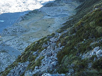
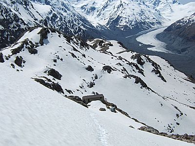
The final scramble off the ridge down to the Ball valley track. The hut ( they call it a shelter) is just inside the shade at top. I spent about 2 hours at the pass, and another 2 hours at Caroline Hut. Now its time to get off the hill. Actually walking time up and over the pass, amounted to 5.5 hours.
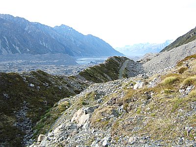
The ball track used to be a road, but so many parts of it have long since slipped into the glacier that they have given up trying to maintain it.
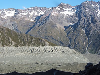
I am right down amongst it now. The lateral moraine wall is basically the result of the glacier receding. Over Time it will vegetate and become part of the mountain. Right now it`s a real mobile and treacherous place for any human.
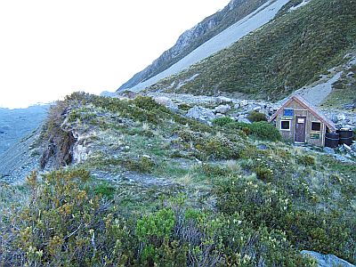
Ball Shelter is all that remains of several generations of Ball Huts--places which climbers used as a base to mount their climbs from.
And it too is destined to tumble into the glacier, as you can see it is less than 10m to the edge or moraine. I can see why they call it it a shelter ( even though it has 5 bunks and a radio). Staying in such a hut for days on end, is akin only to playing Russian rolloute. Nonetheless it`s a nice wee spot, and you literally smell, hear and feel the glaciers presence.
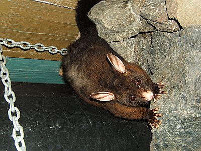
Indeed I awoke at one point to an almighty crack as rocks on the glacier moved. Then a whole family of possums kept me entertained. (Forgot to rotate that one)
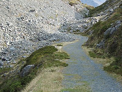
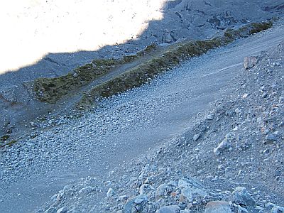
Next day, its back on the road towards civilization. Every now and then the road just disappears beneath of huge pile of rock debris
Nice view of the terrain the ball road traverses.
I get to a point after about 8 days out when im just ready to return, and its arrived. Back to the car to make the universal wrenching decision to leave one truly beautiful place to journey to another truly beautiful place. Sigh, it`s a tough life.
2008-10-25
www.zoneblue.nz/cms/page.php?view=trip9-ball-pass


