Trip13 Matukituki
Date:
8/12/05 - 11/12/05
Highlights
- climbing Mt French a fitting end to my trip
- spectacular upper glacier environs
Route
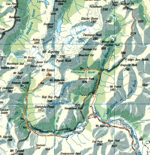
From East Matukituki swingbridge
Rock of Ages biv
West Matukituki carpark
French ridge hut
West Matukituki carpark
Trip log:
Day 1 30km +750m
Day 2 20km +1100m
Day 3 30km +1200m
walked= 80km +3000m=total climb
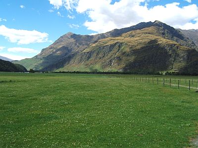
A high off the SW coast of the south island was preventing the low off the W coast of the SI from moving away and as a result inclement weather hung around. I loll around Wanaka resting, and doing numerous small day walks. I learnt my lesson in the Cook area. You cant climb in bad weather. Its not like tramping. Eventually there is a two day window, and I set off up the Matukituki river. Right from the outlet at Lake Wanaka its cold and grey and fast flowing. This gives you straight away a sense of the country youre heading into.
The lower east branch is farmed. You wander with the cows, they don`t seem to mind, unlike the sheep which are not too bright. Then you head into the forest. I had a day to kill till the weekend weather window arived proper and wanted to go up and see the Kitchener basin, which is startling steep country off to the east of the Bonar Glacier. There was also reported to be a large rock biv there.
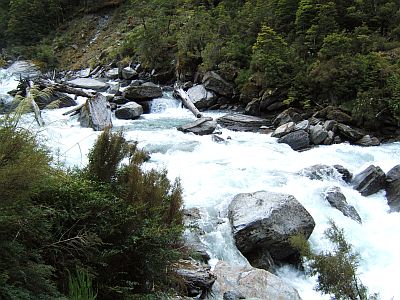
Some way up the Kitchener the river really begins to roar and its clear that it comprises the vast majority of the flow of the entire east branch. It seems to be in flood after the warm week of rain accelerated the spring melt.
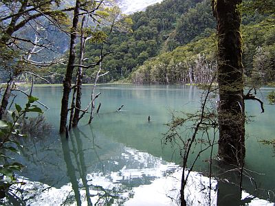
And then suddenly the roar dies off and is replaced with silence. Huh? What happened here then? It seems a side stream has brought down a big avalanche debris and partially blocked off the Kitchener river. As a result the Kitchener flat is now the Kitchener lake. The track is flooded and many places and progress over the flat to the biv is difficult, being a mixture of wading and bushcrashing. The water is freezing.
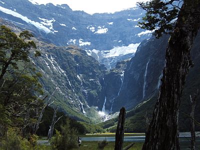
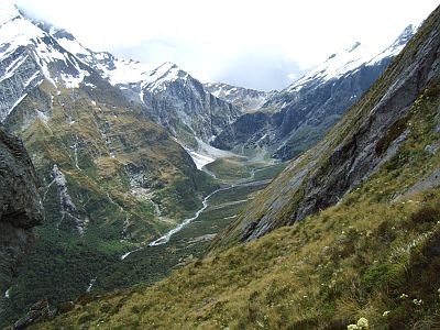
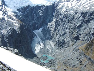
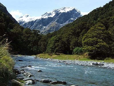
That`s the cirque at the end of the valley, where the rock is almost vertical for hundereds of meters. The Bonar is directly above, and everywhere there are waterfall-lets streaming down the faces. It is an impressive place.
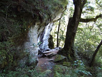
This is the Rock of Ages biv. It`s a massive overhanging boulder. Unfortunately with all the rain, and boulder being schist, um, it leaks (the guide reckons this is all-weather shelter--wrong). I decided not to stay and returned to the car, making for a long day, but will get me off to an earlier start in the morning.
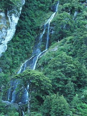
Many dusk waterfalls later, and back across the Matukituki.
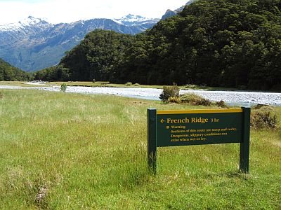
It says no camping at the Raspberry flats road end. However if we did everything we are told wed become rather brainless. Needless to say several parties camped there, I mean this is a valley where for arcane historical reasons they don`t accept annual hut passes.
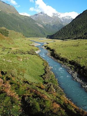
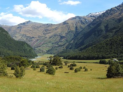
This view is looking up the west branch in the morning. Im tired, and finally manage to struggle out of my warm bed. Following the farm track for an hour or so you come to the huge 1949 Aspiring hut.
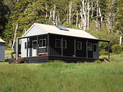
That`s not it, that`s just the wardens quarters. Funky sort of contemporary design though.
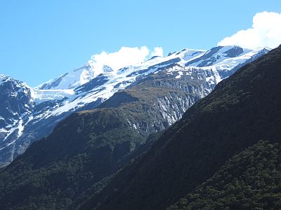
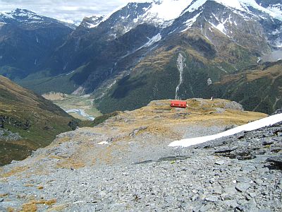
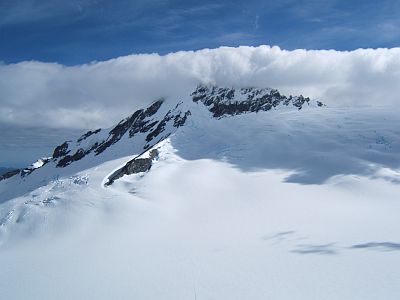
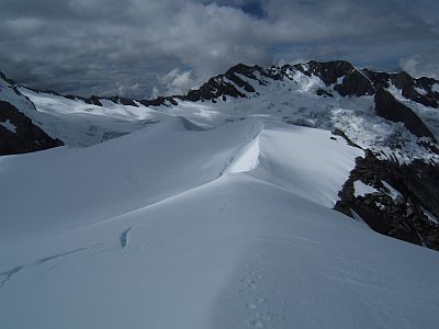
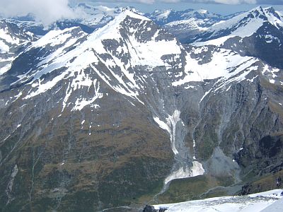
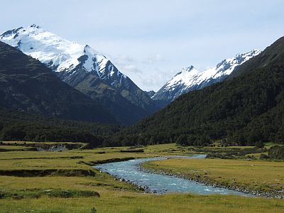
That in a word is French ridge. All of it. First it`s a bush track, then tussolk spur up to the hut, then snow, then crevasse field then the quarterdeck leading onto Mt French, top center, some 2000m above where I stood to take this shot. Left of center is I guess Mt Aspiriing.
The track is a good track but its relentlessly steep. Bordering on rock climbing in places, and im later to realize is the steepest part of the whole route.
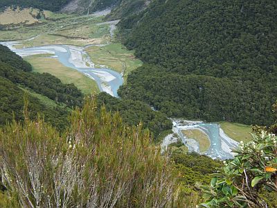
Just though the bush we can see the various flats below.
And the view north is the headwaters of the west branch, and the Matukituki saddle over into the west coast.
French Ridge hut is perched on the end of a spur, and is a scaled down version of the Mueller hut. It sleeps 20. There is a volunteer warden who is Japanese and his version of the radioed forecast is, um, interesting to say the least. It`s a lofty spot to savour the views, but im too tired and go to bed.
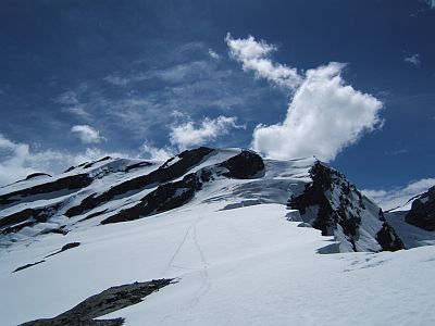
After a brief sleep, darn there is only 6 or 7 hours night around here, an early start sees me and a couple others heading up the ridge. Quickly we hit the snow at about 1900m, and the ascent is relatively gentle. You come to a flatish spot where the risde narrows, with a sheer drop off the corniced right side into the `gloomy gorge`. The snow strangely is firm, and made for easy travel in crampons. I later learn that this is the first freeze in nearly two weeks. Timely, me thinks.
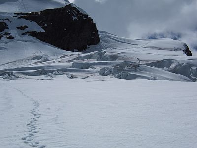
The crevasse field near the top. This is the part that can seriously stop solo climbers like me. Luckily the spring weather has meant the crevices, are not majorly open, and yet also not majorly covered over with soft stuff. Planning this trip, it wasn`t clear whether I would make it up or not, from the people I asked. The ususal advise is go and see, which is what I did. However there were stories from folk at the hut of whole parties being turned back by hidden crevasses, and a massive shrund wall. In this case we sailed up, with some minor weaving, and I reached the top literally before I knew it.
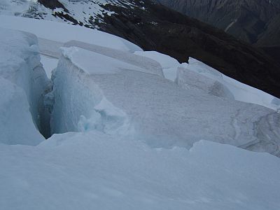
The crevasses were very frozen and pretty stable.
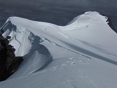
That`s the top of the ridge, named the quarterdeck, and the remnants of the bergshrund (final crevasse). In the distant right is the ridge leading up to Mt French. Just before the peak there is an obvious shrund that might give us some grieve though.
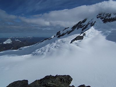
From the quarterdeck you have a clear view of the entire upper Bonar glacier, which in its upper zone is more like a massive snow field or plateau. But make no mistake theres plenty of crevasses, and you only cross it properly roped up. From right to left, that`s Mt Avlalanche, and the birth of the Bonar beneath it is known as the Flightdeck. ( I guess youll figure out the aircraft carrier terminology)
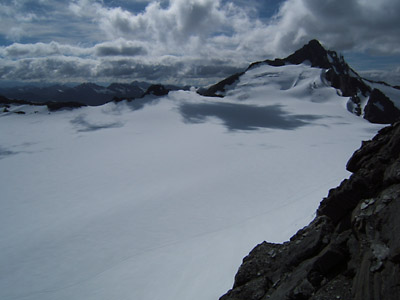
Just some of the vast expanse of the Bonar. The drop in the distance is off into the Kitchener we visited yesterday.
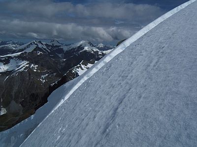
Mt Aspiring which is just managing to hide its summit under the odd northerly airstream.
The north west ridge, which is the easy route up Aspiring, and where the Collin Todd hut is situated near the bottom of the spur at left.
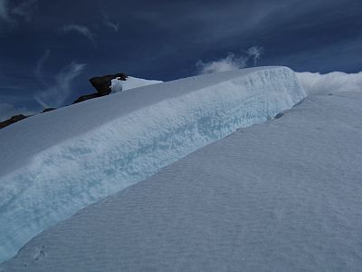
A closeup off the blisters, which to my mid anyway illustrates the snow compaction that occurs in glaciers.
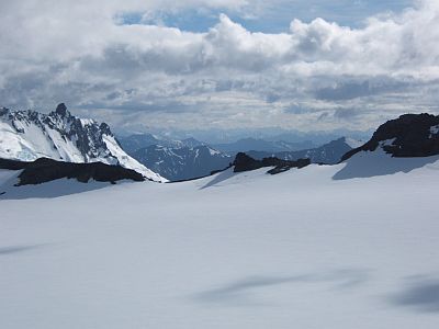
The lower upper Bonar before it drops away to break up to the north. The Bonar is a high hanging glacier, it doesn`t really go anywhere.
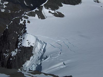
Whats called the Breach, a small part of the Bonar escapes into the Matuki to the west.
Climbing up the ridge I arrive at the shrund. Its about 1.5m wide, 15m deep and 1.5m higher on the far side. Downhill is of course easier. At the far left you just see my footprint from where I jumped over it on the way back. Still, a bit scary.
Anyhow following it to its left I found it tapered off enough to cross. Not without dropping to a part of the slope with some reasonable exposure though. It just seems to get steeper and steeper off down into the Matukituki.
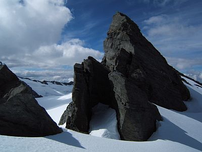
Mt French doesn`t really have a pronounced peak, its more a series of bumps. This is one of the better ones!
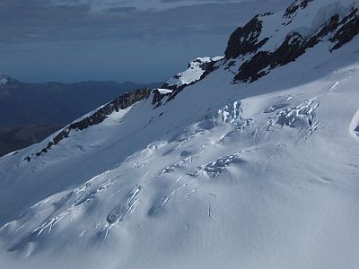
Looking straight down into the Boanr you can see the baby crevasses starting. You can also see the steps of the climbing parties on their way to Collin Todd, and Aspiring.
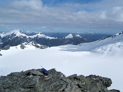
After a snack and some photos, its time to go back. Sad I know. The morning has been a really wonderful and fitting conclusion to my tramping holiday.
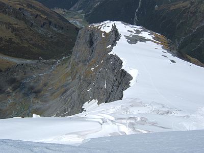
The snow is softening just enough to boot ski most of the way down, so away with the crampons. This shot shows clearly how steep and vast the drop into the Gloomy Gorge is. No one went with 10m of that edge. Probably overkill, but we are a cautious lot.
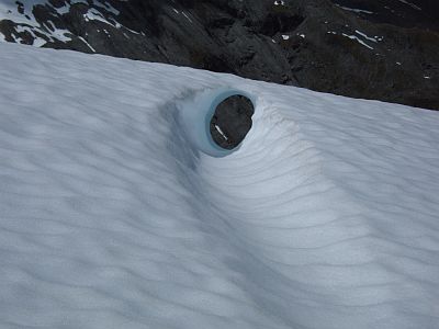
That`s a quirkly little crevasse remnant on the edge of the gulch. Cute, I thought, but no amount of money would entice me to seek a view down there.
Oh, that`s a local character known as Mt Barf. I think we all know why.
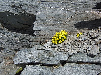
Even before you hit the tussock, this nice little buttercup specimen greets you. That`s hardy for you.
That`s as close as I dared go for the view back up into the head of the Gloomy. Its almost like the mirror opposite of the rampart we climbed up on. Pretty far out geology.
As much as Id like to stay another night at French Ridge, I haven`t budgeted for extra hut fees, and so, after my 6 hour morning jaunt up Mt French, a couple of hour seista, it was time to head off down.
The valley is looking really lovely, and the Matukituki is easy to cross at this point. There is a bridge 1km up stream but its not requred this time.
The big flat before Aspiring hut, the huts at right. Im floating down the valley still high on mountain air.
Its dusk by the time I reach the bottom of the valley, where I camp another night before wandering my way up the west coast to the ferry in a couple days time. I don`t have to stress and rush, which is just fine.
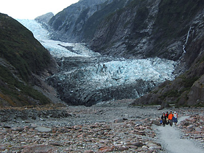
I stop to climb on the hard water ice of both Fox and Franz Joseph glaciers. They are two of three glaciers in the temperate world that come within 250m of sea level. Its fun to front-point my way up onto these dripping creaking beauties, and softens my transition homewards.
The end of the glacier, the beginning of civilisation.
2008-10-25
www.zoneblue.nz/cms/page.php?view=trip13-matukituki


